.
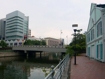
Many merchants, businessmen and coolies, who lived on the Singapore River, were later to be forefathers of Singapore. Soon with creation of the Merlion and more industrial marvels, Singapore's properity grew. Many bridges span the Singapore River.
.
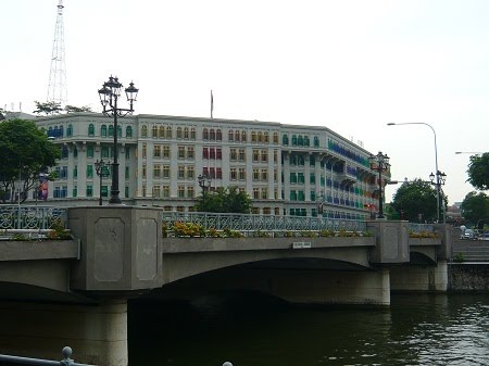
Quaint bridges span the river, ranging from the elegant Anderson Bridge to the simple Ord Bridge. Heading upriver, you will see the historic Anderson and Cavenagh Bridges. Cavenagh Bridge, built in 1869 and now for pedestrians only, leads to Empress Place, which was named in honour of Queen Victoria.

Note: the above map is not to scale
.


^Kim Seng Bridge (1) was named after philanthropist Tan Kim Seng (1850-1864). Located at the point where the Singapore River officially starts, the bridge was built in 1862, and rebuilt in 1951.
.


^Jiak Kim Bridge (2) was built in 1999, near Kim Seng Park. It is one of three new pedestrian bridges located in the Robertson Quay. It is named after Tan Jiak Kim, grandson of Tan Kim Seng.
.


^Robertson Bridge (3) was built in 1998, allowing people to walk across the river in the hotel area.
.


^Pulau Saigon Bridge (4) was named after a small island in the river that no longer exists. The original bridge, built in 1890, was demolished in 1986 to make way for the Central Expressway. The new Bridge, links Saiboo Street and Havelock Road, was opened in August 1997.
.


^Alkaff Bridge (5) was built in 1997. The design of this bridge resembles a tongkang (large flat-bottom barge). It was named after the Alkaff family. In 2004, the Filipina artist Pacita Abad covered this pedestrian bridge in 900 litres of paint in 52 different colours.
.


^Clemenceau Bridge (6) was named after visiting French statesman George Clemenceau. Built in 1920, this large bridge meant to provide an extension to Clemenceau Avenue providing a direct link to Robertson Quay. This bridge is the simplest in design.
.


^Ord Bridge (7) was built in 1886, and connects Magazine Road with River Valley Road. It was named after Sir Harry St George Ord (1819-1895), the first Governor of the Straits Settlements. It was also known as "Toddy Bridge', due to its proximity to toddy shops then. It also marked the landing point for weapons and ammunition which were stored at Magazine Road.
.


^Read Bridge (8) was built in 1889 to replace the original Merchant Bridge, which was too low for boats to pass under. It was named after William Henry McLeod Read, a merchant who successfully petitioned for the Straits Settlements to be ruled directly from London as a Crown Colony. This bridge was a popular venue for Teochew story-tellers to entertain labourers in the 1950s and 1960s.
.


^Coleman Bridge (9) was built in 1840, and named after George Drumgoole Coleman (1795-1844), an Irish architect who designed it. It was replaced in 1865 and 1886, last being an cast-iron structure. Due to roadworks, the bridge was rebuilt in 1989. It was referred to as the New Bridge, lending its name to the road on its southern end – New Bridge Road.
.


^Elgin Bridge (10) is believed to have existed as a footbridge as early as 1819, the year Sir Stamford Raffles landed on Singapore. It served as a link between the Chinese community on the river’s southern side and the Indian merchants of High Street on the northern side. It was once the only place where one could walk across the Singapore River. Elgin Bridge was re-built as a wooden drawbridge in 1822.
.


^Cavenagh Bridge (11) was built in 1869 and is the oldest existing bridge. The cast iron used in this bridge was imported from Glasgow. The bridge was named after William Cavenagh, the last India-appointed Governor of the Straits Settlements (1859 to 1867). It was later reserved for pedestrains only. This bridge had lighting added in the 1990s to accentuate its architectural features. It also has elaborate suspension struts.
.


^Anderson Bridge (12) is a vehicular bridge that is located at the mouth of the river in the Downtown Core Planning area in the centre of Singapore. The bridge was completed in 1910 and was named after the Governor of the Straits Settlements and High Commissioner for the Federated Malay States, Sir John Anderson (1904-1911). During the Japanese Occupation, the severed heads of criminals were hung on this bridge as a warning to would-be criminals. Now, it is one of the key venues of Singapore F1.
.


^The Esplanade Bridge (13) is a 260m-long road bridge that spans the mouth of the Singapore River with the Esplanade to its north and the Merlion to its south. The 70m-wide low-level concrete arched bridge supports two four-lane carriageways and wide walkways . It was built to provide faster vehicular access between Marina Centre and the financial district of Shenton Way. Construction began in early 1994 and was completed in March 1997.
.

^The Bayfront Bridge (14) is a vehicular bridge at Marina Bay. It was officially opened to traffic on April 25. The bridge is next to the iconic The Helix bridge which was officially opened to the public on April 24. The bridge provides a direct connection between Marina Centre and Marina South.
.

^The Helix Bridge (15) is a pedestrian bridge linking Marina Centre with Marina South in the Marina Bay. Located beside the Benjamin Sheareas Bridge, the Helix was officially opened on April 24 2010. The bridge complements other major development in the area, including the highly-anticipated Integrated Resort, Marina Bay Sands, Singapore Flyer, Gardens by the Bay and the 438,000 m² business and financial centre which will be ready by 2012.


No comments:
Post a Comment